Blog Page
YouTube videos, Courses and general news items
This website is now unfortunately closed. I shall no longer be taking bookings for courses. Due to health issues, I am unable to offer classes. The effects of heavy smoking in my younger days have caught up with me – COPD. (I haven’t touched a cigarette in 30 years). Basically, I have to keep stopping to get my breath when ascending hills, because my lungs have lost their elasticity. The booking section of the website has been removed.
I will still be out walking & backpacking, at my own pace, but not taking classes.
Thank you to all those I have taught in the past. Any questions, get in touch via email.
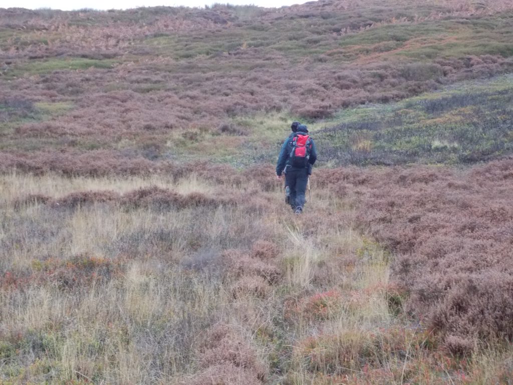
Basic Navigation Course - 15/10/2025
Grinton Moor, near to Leyburn
Jamie who had meant to attend a Basic Navigation Course with Daren on the 10th September with Darren who was now fit and well.
Daren runs a business and they have Wednesdays as a non work day, where the employees do something together “non-work” related. Another member of staff, Steve also attended (Daren was also there, as a refresher & as he enjoyed the original day, he popped along too.)
An enjoyable day with plenty of banter between them, both supportive and less so! However, by the end of the day, they could all read a map and navigate safely, which is the aim of the course. It was great fun!
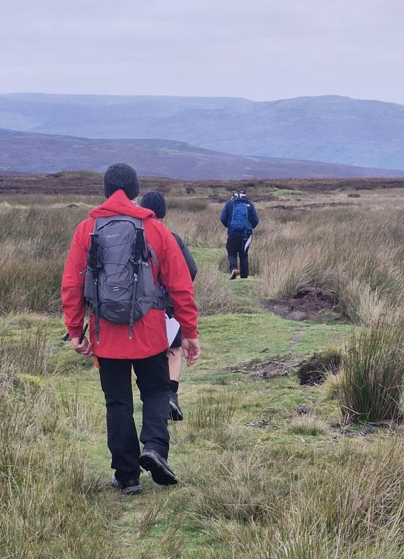
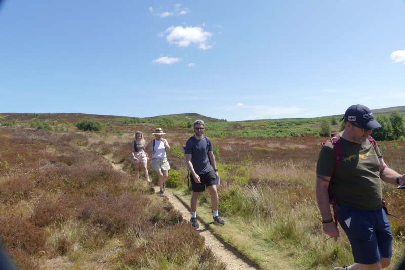
Advanced Navigation Course - 14/10/2025
Chop Gate and Cold Moor
A very full day with Helen & Simon, both experienced walkers who wished to extend their navigation skills. The day was both physically and mentally “exercising”. As can be seen in the photograph, navigating across rough ground with no visible paths to follow. Relying on interpreting contours & using a map & compass bearings.
On the advanced course, there is a lot more use of timing and pacing to confirm your location.
By the end of the day, they had mastered taking and following how to follow a bearing and use the 5D’s of navigation.
It is still important to practice, practice and practice more, once the course id completed.
Course 16/09/2025
One day basic course - Grinton Moor
A one-day basic course with Darren, his mate Jamie was ill so could not attend. No photographs as I concentrate on the client, not on media for my website.
Route planner
Use this planner to think about the 6 D's on your route.
A planning and a safety feature all in one.
It allows you to see how long your proposed route will take, using Naismith’s Rule.
You can also make notes on the back of “waymarks” to tick off or obvious danger areas.
Leave it with a responsible person, just in case.
Powered By EmbedPress
Backpacking Kit List.
The kit list I use to try not to forget anything
Everyone’s kit is different. I use this to tick off, the things I want to take. It is just a reminder, that is always being updated.
It changes with the season and the location I am travelling to. Plus the duration of the trip.
Don’t forget food & water.
Have a great trip!
Is there anything you believe should be on the list.
Please email me with your suggestion.
Powered By EmbedPress
Emergency details page
Leave these details with a responsible person
No one wants an accident to happen; however, as their name implies accidents do happen.
You may know where you are going, but does anyone else?
You are off on a solo walk/backpacking, what would happen if you fell or twisted an ankle, who would know?
Print off this form and fill it out, if you are then delayed for whatever reason, Search & Rescue of whatever type would at least have an idea where to look.
Fill in the route plan, you plan the route, circumstance might change, a route might be flooded/damaged and you can not use it. At least there will be a rough idea where you may be.
Powered By EmbedPress
Day Walk Equipment
Suggested items to carry
This is the equipment kit list that I use whenever I am going out for a day walk, including my day navigation courses.
There is no need to take everything, but it may help you not forget something.
[My most annoying forget – SD cards in camera & action camera.
Ensuring batteries are charged and spare batteries for my cameras.]
Powered By EmbedPress
Website down
A total rebuild required
This website was built by yours truly, as I like to keep my mind active as well as keeping physically active..
My website building skills, are not up to the same standard as my map and compass Navigation Skills.
There was an error in the HTML code. I know what it is, but not how to navigate my way through it.
I would rather spend the evenings working on the website, that watching Drama or Soaps on the TV.
If you spot any glaring mistake please send me an email.
(28/08/2025)
Navigation Training Video
How to read a map
In this video, you follow me as I visit Nidderdale, near Pateley Bridge, North Yorkshire.
My wife was volunteering that day at Newby Hall, so I had 5 hours to occupy myself.
As I drove from Pateley Bridge towards Lofthouse and Scar House Reservoir, my intended location. I saw the possibilities of a walk at a location I had never visited before, the hills above Ramsgill.
I saw it as an opportunity to use some of the 5 D’s of navigation, in this video: Direction, Distance, Description, and Destination.
(15/08/2025)
Walk near to Hawnby
13km Circular walk, Hawnby Cafe
A new cafe has opened in Hawnby, North Yorkshire and having never investigated the road that runs in front of it, I thought it was worth an investigation.
The walk starts at the Hawnby Tearooms and Store, then heads West along hedge-lined roads, with cattle and sheep pastures on either side.
Before long, the road begins to gently gain altitude, passing a Medieval church and the fields becoming deciduous woodland.
Having passed Arden Hall, the now unmade road climbs up onto heather-clad moorland.
Careful navigation is required here, as we are following the remains of ancient field boundaries. It is whilst following the boundary wall we locate a WW2 airplane crash site.
Shortly after this, we descend into a deep valley and then into a Coniferous forest, emerging at Arden Hall.
A walk back along the road to the Cafe and the car park.
(05/08/2025)
Navigation Training video
YouTube - Short - Timing
A YouTube Short, so less than one minute duration, to give you the basics of how to use timing in navigation.
There is a longer, more in-depth video in the series of Navigation Videos.
(30/07/2025)
Navigation Training Video
YouTube -Short - Pacing
A YouTube Short, so less than one minute duration, to give you the basics of how to use pacing in navigation.
There is a longer, more in-depth video in the series of Navigation Videos.
(17/07/2025)
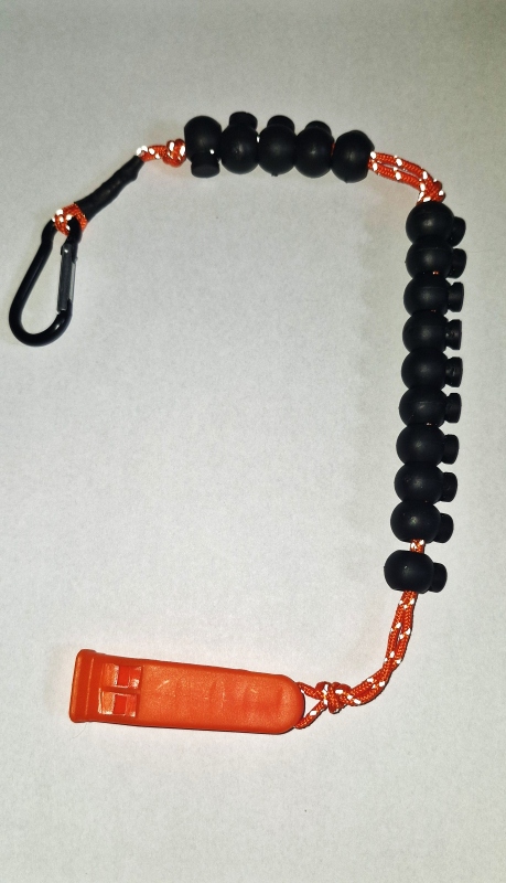
Navigation aid.
Free Safety whistle & Lanyard.
When you attend a Basic or Advanced one day navigation course, you now receive one of these lanyards.
It consists of a very loud safety whistle, and 15 beads.
The bottom set of 10. You move one bead down, for every 100 metres you pace out, so a maximum of 10 x100 metres so a kilometre.
Once you have completed a kilometre, you slide one of the top beads down, and push all the bottom beads up again. to start again.
When you try pacing it is easier to measure in 100 metre blocks.
Plus less chance to forget what number you are at.
(18/07/2025)
Navigation Training Course
Lord Stones & Carlton BanK
The Johnson family joined me on a Basic Navigation Course, starting at the Lord Stones Cafe, near Carlton-in-Cleveland, off the A172.
We started the day with a coffee at the cafe, then had a quick briefing on the pre-read. 6-figure grid reference, etc.
We then measured their individual paces over 100 metres, followed by their km/hr.
Then it was up onto Carlton Bank, on the hottest day of the year so far. The group did fantastically, despite the heat.
About 1 pm, we had a lunch break at NZ504 013, a 4000-year-old burial mound.
After lunch, they were using the map & compass to “aim off” on a bearing to purposely miss their target, so when they reached the fence, they knew they had to go left.
This was followed by contour line interpretation, and uphill all the way. {I had ice cold water bottles of water, in my rucksack, insulated against the heat – much appreciated by everyone!}
Then back to Lord Stones practicing pacing and timing.
An excellent day!
(12/07/2025)
Solo Backpacking trip
Above Scugdale, North York Moors
Early July 2025, a backpacking trip up onto the North York Moors.
It was great to get out again, having gotten over my torn calf muscle back in March.
The weather was hot, 28 °C when I left the car in Scugdale.
Once up on the North York Moors plateau, the walking was easy along the track. Only a short walk
of about 5 km.
However, it was so quiet I could have been anywhere. Just an occasional bleat from a sheep, an
owl hooting or a Curlew calling.
That is the joy of backpacking, getting truly away from it all.
I slept so well that I missed sunrise.
A coffee & breakfast and a return walk to the car, and a bonus, it was all downhill.
Book a backpacking experience and join me next time.
(23/06/2025)
Out of Service - Injury
Calf Muscle injury
Even with the best will in the world, none of us can escape injury.
Did I fall off a mountain? No, I was walking from the harbour at Staithes back up to the car park at the top of the hill. I hadn’t even started to go up the hill, and my right calf muscle tore (whilst on
the flat.)
I will not post the video, my wife took of me, as I hobbled up the hill.
[I would have done the same to her]. The treatment: total rest for at least 6 weeks. Then a period of recuperation to rebuild muscle and fitness, which ruined my intention of walking the Coast 2 Coast in the spring/summer!
That was me out of action until May, frustrated, you bet I was.)
Navigation Course
Basic Navigation Course, Grinton
Monday 3rd March 2025, a Basic Navigation Course with David.
We started the morning with a cup of coffee at a cafe in Leyburn, where we went over the contents of the Basics of navigation pdf, I send to all clients.
After that we have driven up onto Grinton Moor, and it was chilly. .
We measured David’s strides per 100 metres, then we were off navigating.
Using his new knowledge about pacing, we measured the distance to the 1st objective.
We worked out how many paces it should be – bingo. It works, another tool in his navigation arsenal.
Although the weather started out sunny and clear, the weather quickly changed so that visibility became more restricted. Perfect for practicing navigation.
There had to be changes in route I had intended to use, as it was very wet underfoot.
We even had a friendly gamekeeper come over and enquire if we were ok, as we had been in the same location for some time.
We had been taking map to compass and compass to map bearings, so stationary for some time. We had a good chat about the moor.
The day continued with more and more practice of navigation skills, and having the confidence to trust the map and compass.
There are not always visible paths on the ground where public footpaths are shown on the map.
The paths on the ground may be caused by sheep, who don’t take any notice of maps.
Use a bearing to ensure the path you are following is going in the right direction.
David, it was a pleasure to have you on a course.
(03/02/2025)
Navigation Course
Tan End, Hawes.
A basic navigation course, with Vicki & John.
Both had a good amount of experience in hiking in lots of different locations, but felt they needed to update their map-reading skills.
We agreed to meet at the Wensleydale Creamery in Hawes, where we started the day by going through the basic theory of map and compass navigation, over a cup of coffee.
After that, we made our way up onto the fells, via the village of Gayle, then headed southwest up onto the path leading up to Ten End.
For the next four hours, we have practiced using the compass to set our map. Taking and following map & compass bearings.
Pacing & timing for determining distance travelled.
When we got up to Ten End, there was snow on the ground, so we concentrated on keeping safe on a combination of soft snow and ice.
By this time, it was already starting to get dark, and the higher up the fell towards Dodd Fell, the snow got deeper and more icy. We were not equipped for those conditions, so time to return to Hawes.
On the way back, Nicki & John continued to use their maps and compasses to get bearings to fix their location.
Use the slope angle to get their location on a linear path.
They both enjoyed their day and agreed, they had learnt a lot.
They went out the next day to buy their own compass and used it to practice their new skills
Book a course today! Before the best day of your life becomes your worst!
Technology is incredible—but it isn’t infallible. A drained battery, a broken device, or a lost signal can turn adventure into danger in seconds, which is why you should master the basics in map and compass navigation.
Our Map & Compass Course gives you confidence, safety, and independence.  Sign up today – after your next trip may be too late.